AZTech Regional Information System (ARIS)
Back to Projects & Initiatives
Project Description
AZTech is a regional traffic management partnership in the greater Phoenix metropolitan area. All of the major governmental transportation agencies in the region are members, along with public safety agencies and several private technology and media companies.
Led by the Maricopa County Department of Transportation (MCDOT) and the Arizona Department of Transportation (ADOT), AZTech operates through several collaborating committees to guide the application of ITS technologies in support of regional trafficmanagement. The goal of AZTech is to achieve more efficient mobility, less congestion, and a higher level of safety for travelers throughout the Phoenix metropolitan area.
The AZTech Regional Information System (ARIS) is a regional ITS tool that provides real-time incident notification and intelligently assimilates incident-centric traffic information in support of traffic management during an incident. The ARIS system has been designed based on the needs of local jurisdictions who demand timely notification of incidents as they occur in their respective jurisdiction. In addition, upon notification, ARIS automatically assimilates a range of useful information related to the particular incident and presents the information in a webbased "tactical screen" including:
- A map clearly identifying the incident location, speed (and trend) of the nearby freeway traffic detector stations, Dynamic Message Signs (DMS), and Closed-Circuit Television (CCTV) cameras;
- Snap shot images of CCTV cameras around the incident location;
- Messages currently displayed on the Dynamic Message Signs; and
- Charts (histogram) of nearby freeway detector stations showing both the speed and volume distributions since the time of incident.
Different from the do-it-all traffic information web sites, ARIS is highly focused and carefully designed to include only the most relevant information needed in support of traffic management during an incident. ARIS successfully addressed the following challenges involved in managing jurisdictional traffic during freeway incidents:
- The extensive freeway network in the greater Phoenix area runs through many local jurisdictions. Local agencies are not always notified of the occurrence of an incident on the freeway in their jurisdiction. Without timely intervention, the surge of the traffic diverted from the freeway can quickly overwhelm the traffic signals at and near the freeway interchange. The ramp traffic backed up to the freeway mainline increases the likelihood of a secondary accident. The ARIS' geo-query engine continuously monitors incidents within a pre-defined area of interest and provides reliable notifications to the subscribers using e-mail and text messaging.
- To determine the proper intervention, the local traffic operators often rely on multiple information sources in order to gauge the impacts of an incident, including different public and private traffic and traveler information web sites, a phone call to the state DOT Transportation Operations Center, and other anecdotal sources. ARIS addressed this challenge by automatically assimilating all relevant information under one "tactical screen" created for the particular incident. This incident-centric information can be viewed on a computer and a mobile device as well. With ARIS, the traffic operators no longer need to sift through multiple information channels for useful information, rather they can quickly focus on the remedial actions, during the initial "golden period" of incident response.
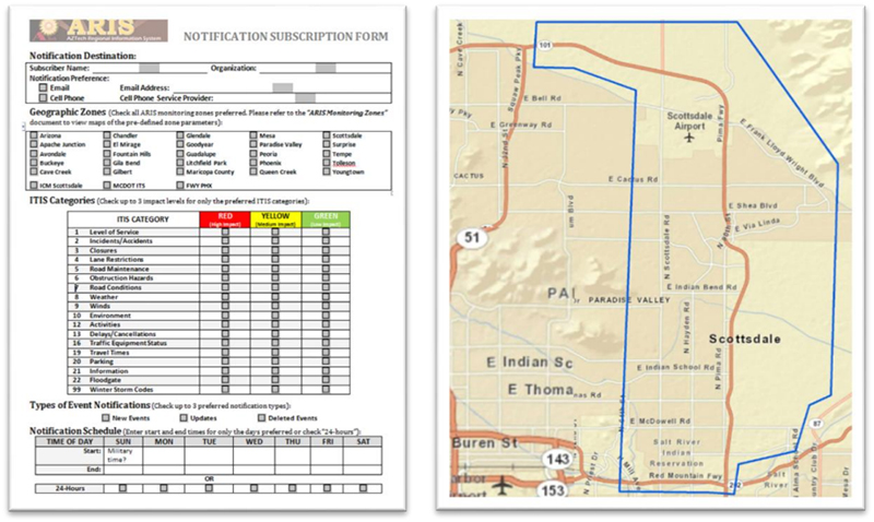
The ARIS is comprised of two major components/services. The ARIS incident monitoring web portal provides a summary of on-going incidents in a selected jurisdiction/zone, and generates a tactical view of each incident containing integrated information including: a live traffic map, CCTV images, dynamic detector station speed-volume graphs, and Dynamic Message Sign content. To ensure timely notification of incidents, the ARIS incident notification feature allows a registered user to receive incident notification via e-mail and mobile phone text message service. Through the registration process, a user can specify the notification method (e-mail, text message), zone of interest, type of incidents (by ITIS code), and notification periods. Figure 1 shows the ARIS notification subscription form and the zone defined for Integrated Corridor Management (ICM) application in the City of Scottsdale.
Since its debut in April 2014, ARIS has proven to be an effective tool for incident management involving multiple regional agencies. A total of 35 clients, representing more than ten agencies and organizations, are currently registered to receive real-time notifications. These agencies include Arizona DOT, Maricopa County DOT, and the Cities and Towns of Phoenix, Tempe, Scottsdale, Chandler, Mesa, Gilbert, Glendale, Peoria, and Surprise. Figure 2 shows the realtime incident monitoring portal.
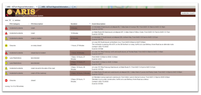
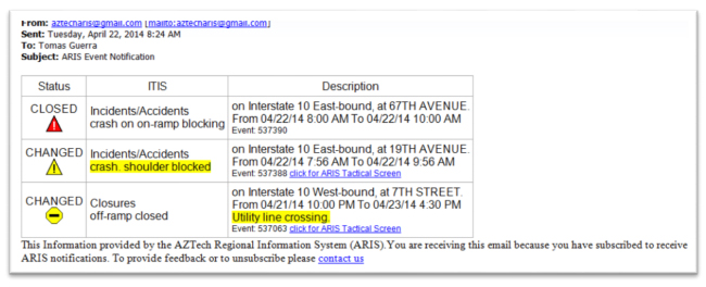
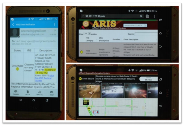
Figure 3 shows an example of the content of the e-mail notification. The message contains useful information on new and updated incidents. For an on-going incident, a web link is included that provides access to the tactical information related to the incident.
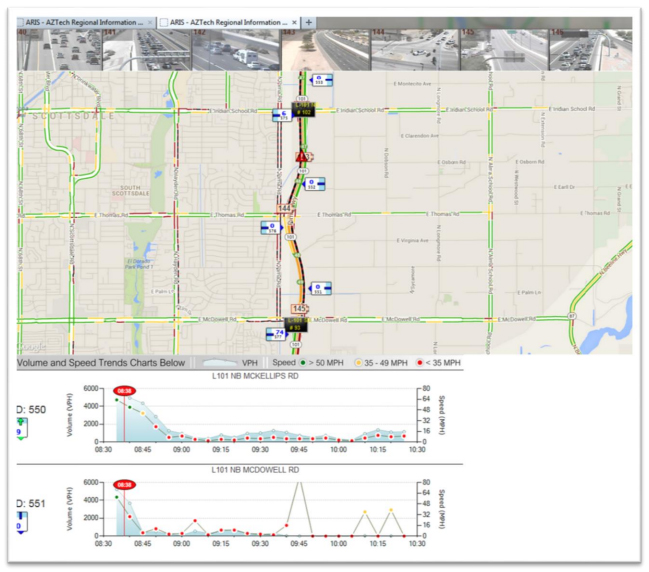
With a single click, AZTech partners are able to see the ARIS Incident Tactical Display, Figure 4, which provides a full picture of the incident impact. The example shows the ARIS tactical screen during a freeway closure due to a fatal accident on the freeway Loop -101 on April 25, 2014. The time and extent of the closure are accurately represented in the volume-speed graphs generated based on the real-time freeway detector data. The incident time is clearly indicated in the graph using the red pin-cushion marker, providing a useful visual reference on the change of traffic flow at the particular location. For example, notice that the freeway volume and speed both drop to zero during the course of the incident.
Designed to deliver a mobile-device friendly interface, Figure 5, ARIS incident notification and Incident Tactical information can be viewed effectively on a mobile device such as a tablet or smart phone.
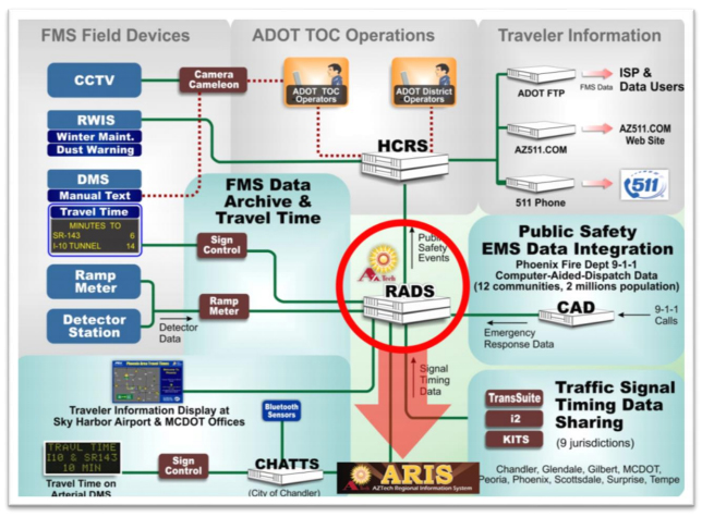
ARIS is closely integrated with the AZTech Regional Archive Data System (RADS) which is a processing engine and data archival system of ITS data in the greater Phoenix metropolitan area since 2001. ARIS leverages the existing data currently integrated in RADS and employs intelligent logic to provide highly useful information in support of regional incident traffic management (Figure 6).
Since its deployment, ARIS has generated over 900 notifications per day to its 35 registered users. These represent an average of 18 closures, 200 lane restrictions, and 60 maintenance events on a typical day.
ARIS is well received by the transportation management agencies and was the winner of the 2014 Best Use of ITS Industry Product or Service Award of the Intelligent Transportation Society of Arizona.
For more information, contact:
Faisal Saleem
ITS Branch Manager
MCDOT SMARTDrive Program Manager
Maricopa County Department of Transportation
602-506-1241 / Faisal.Saleem@Maricopa.gov